

Attraction
Recreation


In the historical topography of Khiva the traditional principle of town design included a castle accompanied by its distinctly configured parts: an ark-citadel, the shakhristan (city proper) and a rabat (suburb). The Itchan-Kala (shakhristan) was enclosed with strong walls, around which there were quarters of suburbs, the Dishan-kala, which in turn was also surrounded by walls.
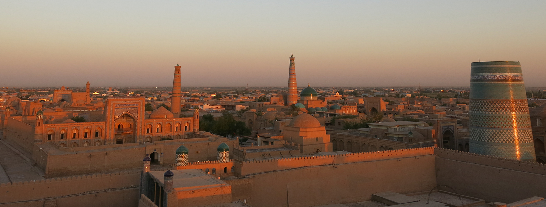
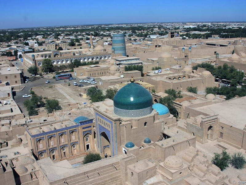
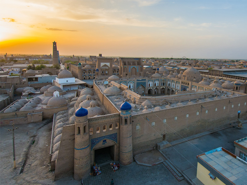
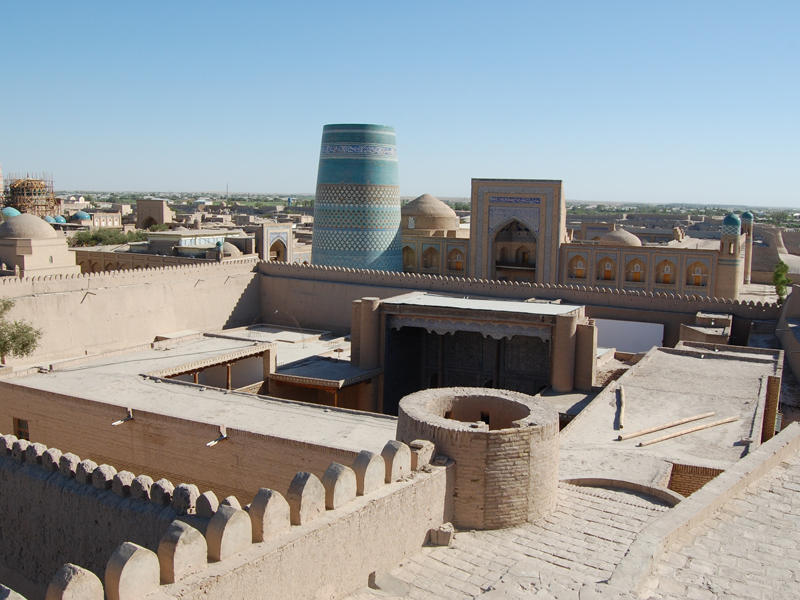
In the plan, Khiva was a settlement of irregular outline, stretching from the west to the east and extending outwards on its eastern end. From the south to the north the distance between the extreme points of the contour of the walls of the outside Dishan-kala was about 2.5 kilometers in length and 2.5 kilometers in width. In the center of this territory was the inner town Itchan-Kala with its location on the east. Its area was fifteen times less than the total area of the town square. The Itchan-Kala, elevated over the suburbs, was constructed according to the ancient traditions of Central Asian town planning, as in many other towns (Bukhara, Paikend, Shakhrizabz). It was shaped in the form a right rectangle (650 by 400 meters), which stretched from the south to the north and was closed by the border of the town's defensive walls. The Itchan-Kala was divided into four parts by the two intersecting arterial roads, which connected the four town gates located in the southern, northern, western and eastern walls.
The suburban streets of Central Asian towns usually corresponded to the historical transportation routes, which led to the other towns of the country. Thus, when the Dishan-kala was constructed in Khiva, these roads were preserved going through the gates, which were built into the town walls. To the east were the Khazarap (Koy-darvaza) and Pishkanik gates; to the south were Toza-bug and the Bagishamal gate, which were also called the Angarik (Yan-gi-arik) and Shikhlar (Shekhlar); the Shakhi-Mardan gate was on the west side; the Dash- (ayak, Gandimian, and the Qadailar gates, situated near town's area for paupers (Qadailar), led to the north, and lastly, the Kosh-darvaza double gates were on the northern road to Urgench. The Kosh-darvaza is still intact and is used today.
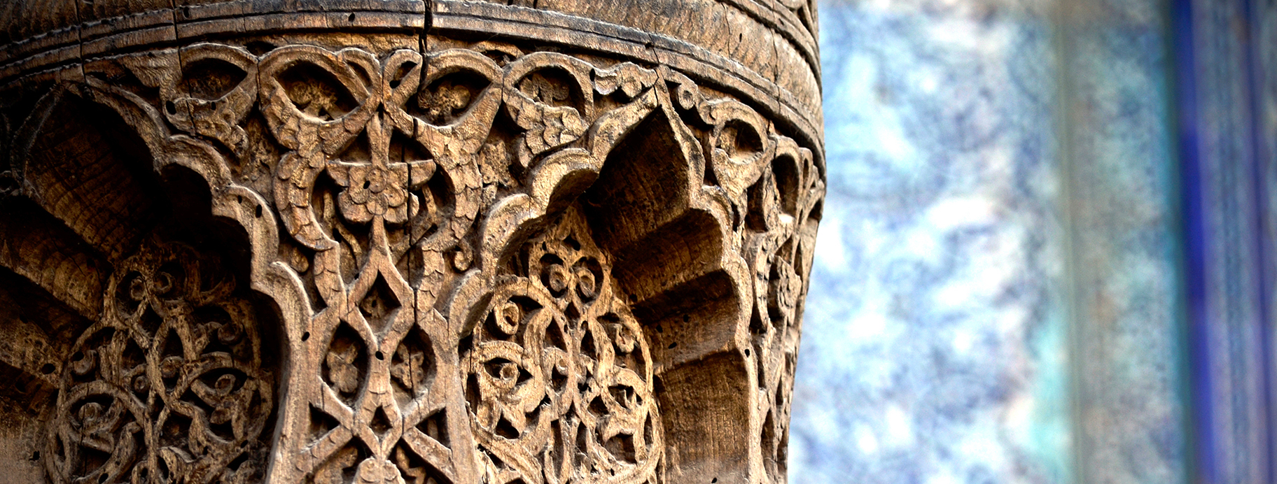
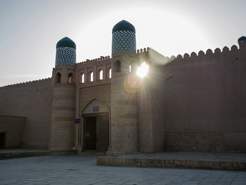
The walls of the Itchan-Kala with a height seven or eight meters were made of rows of pakhsa and in the lower part they were made of large adobe-yolks. Along the perimeter of the Itchan-Kala walls, massive round towers were constructed at approximately every thirty meters. The gates and walls of the Itchan-Kala are examples of fortifications from the middle ages, which are yet preserved today.
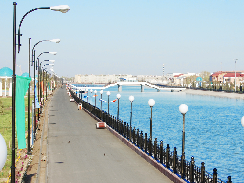
The Dishan-kala did not have the characteristic, outwardly protruding, radial-circled configuration, as Tashkent did, for example. The network of town blocks which surrounded the Itchan-Kala, with their complex layout were oriented towards its walls and the arteries of roads and water canals, which cut through the town. The inhabited areas of the Dishan-kala were concentrated at the lower part of the northern, eastern, and western facades of the Itchan-Kala. The western part was covered with ploughed fields and gardens of the nobility. Only one large and full-flowing arik (small man-made canal), the Sirchali, went around the town from southwest to northeast with its branches on the territory of the Dishan-kala. From the north, the current of the Palvan-yab arik limited the outline of the Dishan-kala walls, and from the south the Zakkash canal bordered it. These water lines served as natural boarders of fortification for the inner circle of the town walls.
The historical topography of the town was formed not only from the natural landscape, for example, the hills of Itchan-Kala, which were life-giving water sources; nor was it limited only by the historical ties which Khiva had with its neighboring settlements and contiguous countries, but the social structure and the cultural life of the Khorezmians also affected the construction of this post-feudal town.
Khiva became the capital of the state in 1556 under the rule of Dustkhan ibn Budj-chi, according to P. S. Zakhidov; however, according to the view of ?.?. Afanasieva it was during the rule of Asfandiyar-khan I (1623-1642) and Abdulgazi-khan (1643-1663). Nevertheless, its intensive development began during the rule of Arab Mukhammad-khan (1602-1623), when monumental constructions were begun like the madrasa of Arab Mukhammad-khan (1616), the mosque and bathhouses of Anush-khan (1657), and the madrasa of Khodamber-dibay (1668).
Economic and political crises in the country and kaleidoscopic changes of rule due to power struggles between khans (khanbozi) disastrously influenced not only the life of Khiva, but also the whole of Khorezm. Furthermore, the occupation of Khiva by troops from Iran, headed by Modir-shakh, in 1740, resulted in the destruction of the country.
It is probable that during this period of the khanate's economic and political instability, the territory of the town (shakhristan) decreased considerably. A castle wall was erected around the town and the map made by Mazimov, verifies this. Large fortification works were kept in the Kukhna-Ark (1686-1688).
At the end of eighteenth century under the power of kungrad Mukhammad Amin-inakh (1763-1791), who straggled for Khorezm's unification, some political stability was gained which positively influenced the state of the town. Munis writes that by 1782 the work on Khiva's restoration had been completed. More specifically, the walls and towers of the Itchan-Kala were repaired and all the ruined buildings of the town were restored. The madrasa of Khodamberdibay was restored once again. Besides the work of restoration, new construction was begun. Thus, the madrasahs of Shegazi-khan (1765) and Mukhammad-Amin-inak (1765) were erected. The Djuma mosque with its minaret (1788-1789) was reconstructed and considerably expanded on the site of the old mosque.
The years of Mukhammad-Rakhim-khan's rule (1806-1825) were marked by the unification and strengthening of the Khiva khanate. At the end of the eighteenth century and the beginning of the nineteenth century, trade with Russia (i.e., in the areas of the Urals, the Volga and Siberia) was increasing, which brought about a strengthening of the economy of the khanate and the development of Khiva, Hew Urgench and other towns. The greatest number of architectural monuments was erected in the nineteenth century. Furthermore, they constitute the architectural identity of the town, which is yet preserved up until the present time. In that period, Khiva was growing considerably in area and its boarders went far beyond the limits of the ancient and medieval town.
At the beginning of the nineteenth century the capital of the Khiva khanate turned into a vast construction area. Large construction works were conducted at the eastern gates — the Palvan-darvaza. An eyewitness of these events, Khudoiberdi ibn Kashmukhammad, a court historian wrote: «They (also) say, that Khiva was subjected to destruction many times and was again restored. It was modernized by the late father of his majesty (Allakhkuli Bakhadur-khan), forgiven by Allah and now in Paradise, as well as by Abui-Qazi Mukhammad Rakhim-khan and his brother, the late Kutloog Moorud inak, who was famous all over the world. Thanks to their attempts the then-great madrasa Kutloog Moorud inak was constructed.
A significant contribution to the construction of Khiva made was made by Shirr divan-begi, one of the eminent slaves of the aforementioned imam and his vizier Mukhammad Riza Kushbegi, on the khan's order a caravanserai and a covered bazaar (tim) were constructed near the madrasa of Allah Kul Khan. In the eastern part of the Itchan-Kala the palace complex called the Tash-khauli was erected. According to Agakhi's information, after the military campaign to Merv, Alla-Kul-khan visited the Tash-khauli palace, some part of which had been completed by his return. Mukhammad Yakub Mekhtar was responsible for this» the chronological table (ishratfazo ma-kome) gives the dates of 1248 N. (1883 A.D.) In 1883 the Tim of Alla-Kul-khan was constructed. And, finally in 1250 (1834), the construction of the madrasa of Alla-Kul-khan was complete on the eastern side of the madrasa of Khodamberdibay.
Agakhi wrote about the construction of this madrasah: Between the caravanserai and the gates of the Pakhlavan-Makhmud (Palvan-darvaza), on the order of Alla-Kul-khan, a high madrasa was constructed, the portal of which faced towards the side of the madrasa of Kutloog Moorud inak (constructed in 1806-1807- AD), creating the grouping called kosh. In the course of the construction of the madrasa of Alla-Kul-khan, the madrasah of Khodamberdibay was basically reconstructed, To make the kosh on an east-west axis from the madrasa of Kutloog Moorud inakf an entrance room with a cupola form was erected, which divided the madrasa of Khodamberdibay into two yards, which were unequal in size. The door and a marble slab from the (then) closed main entrance were transformed into to the entranceway of the northern yard, Mukhammad Riza Kushbegi was responsible to inspect the construction and after his death Imam Kushbegi had this job. The repairs of the surrounding buildings were also their responsibility. The constructions of the Tash-khauli were completely finished in 1838. During the next two years (1838-1840) the Anusha-khana bathhouses and the Ak-mosque, which had been erected already in 1265-6 (1658) were restored, and the Palvan-darvaza was also reconstructed.
In 1840 on the order of Alla-Kul-khan, a ramshackle wood-frame building, the madrasah of Mukhammad Amin-inak, was reconstructed; Mukhammad Yakub Mekhtar was appointed to be responsible for it. By that year the ensemble at the eastern gates of the Itchan-Kalahad been virtually completed. At that period large construction work for the erection of the mausoleum of Palvan Makhmud and repair-restoration work on the mausoleum of Said Allautdin and Kukhna-Ark was undertaken.
In 1842 under the direction of Mukhammad Yakub a strong six-kilometer fortification wall with ten gates was constructed in thirty days around Khiva. The country palaces of khan Ratfink, Hurullabay, and Nurullabek touched on the precincts of the town. Since that time this part of the town's territory started being called Dishan-kala (outer town or outer fortress).
After the appearance of the outer wall of Khiva, the part of the town surrounded by the small circle of fortification walls, with a length of 2100 meters, received the name Itchan-Kala (inner fortress). Then, in honor of the town's reconstruction, odes of praise were composed. Agakhi defined this time of the construction of the fortification walls, saying: “Hisori hoosh bino”, (the fortress has been erected well-proportionally). This was in the year 1256 (1842).
He spoke further about the Dishan-kala: An outer wall had been constructed in 1842, a month before the khan entered Bukhara. It comprises, together with the town, a part of the suburbs now included into its territory, and has an irregular form; its circumference is six versts (a verst was equal to 3500 metres) and 100 sazhens (a sazhen was 1.6 metres; the total was 2,134 metres), other sizes are equal to the internal wall; of the twelve gates made in this external wall, only eight are made of bricks and are decorated, as for the others, only their openings were left. In Khiva there are two khan's palaces, seventeen mosques, twenty-two madrasas, a caravanserai, covered rows and about 260 shops scattered about different parts of the town, along the external wall of the town between the Bakhcha and Shirr-Mukhammad-Ata gates.
Further, he describes in detail the Palvan-Ata mosque (mausoleum of Pakhlavan Makhmud), the mosque of Said-bay (madrasa and mosque of Said Shalikar bay), the khan pal-ace, arik of Kun-Ark, the caravanserai, and the madrasa Kutlu Mrak Inakh (Kutloog Moorud inak).
The population of Khiva does not exceed 4000 total (perhaps he meant only the population of the Itchan-Kala, — editor} and consisted primarily of officials, the clergy, and the merchant class. Sarts prevail in numbers; thereafter come Persians and then Uzbeks. The suburbs consist of developed fields, gardens and houses, belonging mainly to the khan and his retinue, including the most cozy and beautiful one — the khan's house Angeric (he meant the suburban palace of Bagi Shamal, editor).
The above mentioned description of the town was of the greatest scientific value due, in part to the map made by Baziner, a participant of the expedition, According to the map, the dominant part of the town's plan was still the west-east road, and the intersection of the main roads of shakhristan which did not develop as much, apparently because there was a lake at the southern walls and the gates had not yet been constructed. They, as it is seen from the plan of the town Lusilin, appeared only in 1873, to be more precise, at the period from 1858 to 1867, when along the reservoir sewage was discharged from the Zeikash canal. The Angarik Lake went from the east to the road that connected the Tash-darvaza and the Dishan-kala gates, which was shown the twentieth century plans of Imatullo Matkarimov (1920) and Migmatullaev (1922).
In the second part of the nineteenth century, intensive construction was carried out in the area of the Itchan-Kala, near the western gates. The madrasa of Mukhammad Amin-khan with its minaret (1851-1855) as well as the madrasas of Mukhammad Rakhim-khan 11 (1871) and Matniaz Divan-begi (1871) and a number of other objects in the central part of the town were erected.
After the invasion of the khanate of Khiva by Russia in 1873, with the centralization of the power and the unification of the khanate lands completed, some favorable social-economic preconditions for significant town-planning measures appeared. The capital was decorated with monumental buildings. Highly engineered construction, appearing in the form of interior and facade decoration, penetrated the traditional architecture. It was especially notable at the beginning of twentieth century in the construction that appeared in the northern part of the Dishan-kala and behind the gates of the Kosh-darvaza. Elements of regularly planned construction can be clearly seen there.
Construction was also begun in the area of the Dishan-kala. Behind the Ata-darvaza gate the complex of Bikadjan-bik (1894) was constructed, as was the complex of Tort Shabbaz 1885), the madrasa of Said Mukhammad-khan 1863-1864), and the madrasa of the palace of Hurullo-bai; and many others were expanded. Home dwellings were closer to the central parts of the town and the public, social, and political elat centers (makhallas), were connected, in general, to the family and the professional trade-associations that were formed. Sometimes in such centers, madrasa-mosques, water-reservoirs, and trade shops selling every day goods were built. Some examples were the mosque and water-reservoir in the elat Kaptarkhona, the Mukhammad Makhram madrasa mosque with a minaret and others.
A map made in 1920 by Imatullo Matkarimov gives a good picture of Khiva of the beginning of the twentieth century. It is remarkable that not only data on construction, but also basic information on the population, the land area and the number of mosques and madrasas are indicated there. By 1920, according to the Matkarimov data, 4949 families (27,088 people) lived in Khiva, including 909 families (13,767 people) in the Itchan-Kala and 4040 (13316 people) in the Dishan-kala. All in all, there were seventy-nine mosques and forty-three madrasas. The area of the city was about 468 tanabs (a madrasa tanab is equal to sixty gazas and a gaz is equal to 0.5 arshin, or 0.71 metres). The construction of the Islam-Khodja madrasa and minaret and the building of a Russian local school a post, a hospital, and a court for the official reception of Asfandiyar-khan, and the country palace of Kibla Tazbug and others were completed during this period of time. By 1922, when Khiva was already part of the Khorezm Republic there were sixty-four madrasas in the city, of which twelve had been in ruins or were destroyed, as well as eighty-four mosques, including thirty-four in the Itchan-Kala and fifty in the Dishan-kala.
Up until the 1950s Khiva had developed spontaneously, without a general plan. Flotkin, marking the achievements in the field of architecture and town planning, wrote: «The epitome of creativity of Khiva architecture of the nineteenth and early twentieth centuries is mostly seen in ornamental-decorative art and in wonderful pieces of civil architecture, closely connected with the experience of mass folk architecture».
With all achievements of the pre-Revolutionary years, the architecture of Khiva, in general, underwent a definite depression. The momentum of architectural thought in the country came to a halt, and some attempts at a mechanistic connection between folk ways and Russian-European culture was not to succeed, until new conditions further defined the development of the architecture of Uzbekistan along the lines of ideological-artistic and technological progress.
In 1925, after the state demarcation of Central Asia, «Turkomstaris» was renamed «Sredaz-komstaris». The main responsibility of this committee was the maintenance and restoration of the monuments of history and culture, which were in great need of restorative work. Obviously, territorial remoteness from the principal cities, the consequences of civil war, and economic dislocation precluded the opportunity to conduct scientific-research or undertake restorative work in Khiva, as was also in the case of Samarkand and Bukhara.
In 1937, «Sredazkomstaris» organized the Khorezm archaeological expedition, headed by ?.?. Zasipkin, Ya.Q. Quliamov, R. Habiev, T.S. Stramtsova with post-graduate students S.S. Ratia and U.A. Egorov from the Moscow Institute of Architecture and others. The multi-faceted activity of the expedition included n only the study of the monuments of archaeology and traditional dwellings, but also the undertaking of urgent restorative initiatives. Master craftsmen were enlisted in the service of the restorative work. Hence, the People's Master, A. Baltaev, took part in the restoration of the Kurinish-khana of the Khukhna-Ark. Under his advice and leadership the ceiling of the aivan room and the overhead cover of the court were restored with the authentic techniques of ancient painting. Restoration work on the Palvan-darvaza fortress gate and the guldasti of its eastern fagade was also completed.
In 1946 a new stage was reached in the direction of the preservation and research related to the architectural monuments of Khiva. Under the leadership of architect R.R. Abdurasulov, the bath house of Anush-khan, the Ak mosque, the mausoleum of Said Aladdin, the madrasa of Alla-Kul-khan, the mosque of Bagbanli, the complex of Said Shalikar-bay and the madrasa-mosque of Ibragim-khodja all had restorative work done on them.
After the Great Patriotic War, as a result ? the work of restoration carried out in ruined cities and towns, a new and greater under-) standing in architectural practice emerged regarding of the preservation of monuments as an important aspect of the local environment in ancient towns. The practice of having restricted areas around monuments and the establishment of protected zones came about All of which required detailed research as well as the implementation of practical measures.
In 1946 The Scientific Council for the Preservation of Monuments under the Soviet of Ministers of the USSR made a decision regarding their intention to establish the Itchan-Kala as a reserve, which was taken into consideration when the architect of the Uzgosproekt, F.I, Dolgov was working out the plan for the reconstruction and general re-planning of Khiva. As a result, the Itchan-Kala was left without changes, with a green strip along its walls.
“MIT.UZ – 2016” Sovrindori “MIT.UZ – 2015” Sovrindori © Saytdagi materiallardan foydalanganda manba www.xorazmiy.uz ko`rsatilishi shart. Murojat uchun info@xorazmiy.uz Yaratuvchi Double Bride Softs